Before scheduling a private utility markout service for your site, try to find related utility maps whenever possible. They might provide important clues for utility locators to locate some underground utilities. Of course, there are many utilities buried without any records. Also, if there are records, they could be inaccurate or outdated. But it doesn't mean they are not useful. Underground utility locators work like detectives: not every clue is useful and some might be even misleading, but some clues could lead to important discoveries. For the best result of underground utility locating, try to help your utility locator by feeding him/her with clues such as utility maps, historical documents, or even telltales about the site.
During an underground utility locating survey, I was trying to locate a sanitary sewer pipe as well as other utilities. The sewer pipe could not be detected with GPR, mainly due to the limited GPR penetration depth. The sewer pipe was made of PVC, so it would not show up in sweepings using pipe/cable locators either. Fortunately I got the utility map from the client, and the map showed there were some clean outs, which were supposed to be at where the pipe made turns. Through the GPR survey, I did find these clean outs, either buried under soils or covered by dirt. So I was able to accurately identify the pipe location by finding these clean outs . If I don't know there were clean outs, or worse yet, if I don't even know there was a sewer pipe, I could not locate the pipe accurately or could even missed the pipe completely.
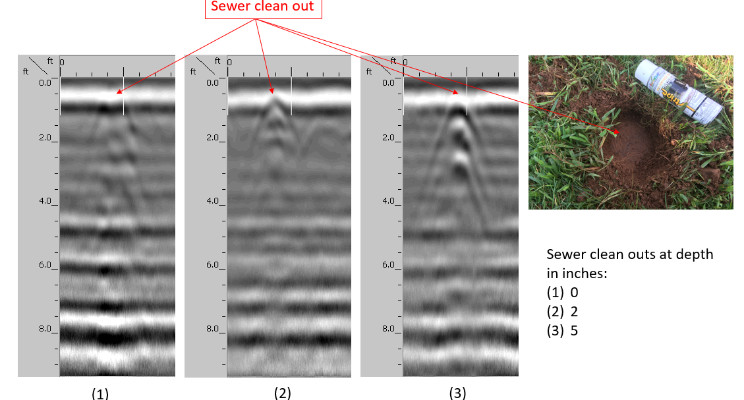
The GPR data images show the 3 clean outs. Each clean out was about 6 inches in diameter. The main differences among them were their buried depths. The first one was right on the ground surface with only a very thin layer of dirt over it. The second one and the third one were about 2 and 5 inches deep, respectively, covered by soils and grass. All these clean outs were in the same lawn area. With only slight depth differences, these very similar objects showed up in GPR data quite differently. The signatures of these clean outs in GPR data can be mistakenly, but easily, interpreted as tree roots, stones, small junk metals, soil disturbances, etc. We see these similar signatures all the time during GPR surveys, and signatures from clean outs don't necessarily stand out from them. Remember the fact that a GPR operator generally needs to interpret what's in the data on the fly and doesn't have much time to analyze every anomaly in details. I was able to locate them because I knew they were there and approximately where to look for them. The utility map I got from the client played a critical role in locating these clean outs, and consequently the sanitary sewer pipe.
In many cases, utility maps often provide vital clues to those easy-to-miss utilities such as PVC pipes, fiber optic cables and utilities buried unusually deep. Providing utility maps to utility locators is one of the best things you can do to achieve best utility locating results.


