During a survey for locating underground utilities, access to the survey area is apparently needed. However, due to the lack of understanding of how underground utility surveys are conducted, survey sites are often found not prepared well for access after surveyors arrive. As a result, survey results are often less ideal and sometimes surveys are not effective at all.
Most people understand that a survey area needs to be “scanned”, so the access to the survey area, at least in a walkable condition, should be granted. However, this is only the minimal requirement for the access. The whole access issue is far more beyond that, especially when the ground penetrating radar (GPR) depth is limited. When the GPR performance is poor and the surveyors have to rely heavily on cable/pipe locators for the survey, the access issue usually becomes more important. Even at sites where GPR performances are great, good accesses might still be helpful for identifying or confirming utilities. Understanding well about the access issue could help you to better use underground utility locating services and make your money well spent on them.
Access issue 1: Ground obstacles.
This issue is easy to understand. Ground obstacles will limit a surveyor's ability to "scan". For example, if you have a parking lot full of parked vehicles, apparently these vehicle occupied areas could not be scanned. But their existences could extend their problems beyond their occupied areas. For example, a manhole could sit right underneath a vehicle and it might be possible that its associated utilities, which may go under occupied and/or open areas, could only be located through accessing the manhole.

Another kind of good examples of ground obstacles are construction materials. They are often heavy, piled together and not easy to move around. They could cause even worse issues than vehicles. For the vehicle issue, at least you can observe what's underneath them. If you see a manhole, valve or an utility box, at least you'll try to look for their associated utilities. If you are not even aware of their existences, as they are covered by construction materials, you don't even try to look for associated utilities. Basically, if a surveyor knows there is an utility somewhere around there, he/she will have a less chance of missing it.

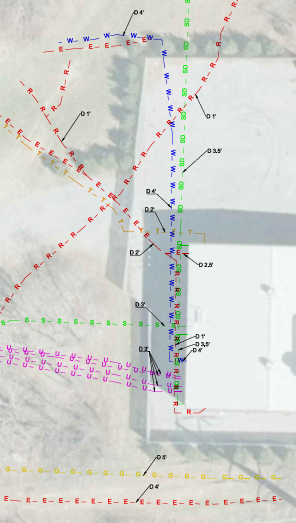
Access issue 2: Access outside the targeted survey area.
This issue is often unrealized or forgotten by many people, hence it's more important to keep it in mind when you schedule an underground utility survey. Why do we need access to the areas outside the targeted area? A good example is actually already mentioned above in access issue 1: the access to a manhole might be the only chance of locating its associated utilities and the manhole doesn't have to be inside the targeted survey area. Another good example is shown in the picture below. The electrical conduits outside the wall were made of PVC, and the best way to find out where they go was to put a clamp around them to generate a signal for tracing using a cable/pipe locator. Unfortunately it's an area enclosed by fence without access.

Another example is shown in the picture below: an utility line was found at a corner of a targeted survey area. It's actually found through accesses to areas outside the survey area. This was at a corner of a construction area so the door next to it was blocked for safety reasons. Fortunately there was an access through other doors. The surveyor had to get out of the building, and then went back into the building through another door to get to the other side of the blocked door shown in the picture. It was a long walk back and forth for dozes of times.

Access issue 3: Access to nearby buildings
There are usually very good access points inside buildings such as basements and utility rooms for locating underground utilities outside buildings. In a basement, usually you can see where all the utilities come in and trace from there. In the picture shown below, there were 4 sanitary sewer and storm drain pipes going out through the basement wall. They were very close to each other (about 8 feet span from the leftmost pipe to the rightmost one) and their depths varied from about 4 to 7 feet. The GPR penetration depth in the outside survey area was very limited. Without the access to the basement, either their locations would be marked less accurately, or one or more of these pipes could be missed, most likely the deep ones.

It's a similar situation for an utility room on the ground level. Although it might not be as clear as in a basement, at least you can get a general idea where the utilities come in. As shown in the picture below, several electrical, water and other utilities, rose up from the ground at the corner of the building. Without the access to this room, the utility locating outside would be less efficient and the chance of missing one or two of these utilities would be higher. The access is particularly important when utilities lines are clustered together; and the chances of missing small diameter, deep, or non-metallic utilities can be greatly reduced.

For security and safety reasons, survey sites or areas are often fenced/block in, as in many construction projects. For the same reasons, utility facilities, such as electrical power substations, gas pipe facilities, water towers, sewer pumping facilities are often fenced in. “Secure areas” in or around targeted survey areas often cause access issues and consequently less effective underground utility surveys.
It's not uncommon that the access issues are brought out too late for underground utility surveys. Once the surveyor arrives the site, you may not have enough time to reach people to remove their cars, get to the right person to open a door/gate, or get a permit for accessing certain areas. Planning ahead is helpful and sometimes is the key for a successful survey.


